Estimating Software Technology
What? You’re not using geospatial generated estimates? Read this article to find out why you should start.
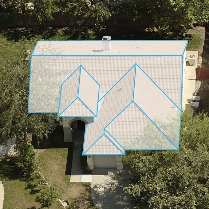
Exterior estimating software has come a long way in the last decade, and both contractors and insurance adjusters are reaping the benefits. The technology has become so reliable, that scampering about on a steep roof and slogging around in the rain with a tape measure and soggy notepad are becoming a thing of the past.
We sat down with a long-time insurance adjuster and also spoke with the folks at EagleView, one of the principal players in the estimating software industry. If exteriors are your thing, here is how you can take advantage of this high-tech tool.
On This Page
What Is Geospatial Technology?
Geospatial technology is a fancy way of saying mapping. The companies that have created geospatial estimating software can achieve are achieving an incredible level of accuracy by using images captured by satellites, airplanes, and drones.
How Does Geospatial Estimating Software Work?
First, you let the estimating company know which house you want an estimate report on, usually by placing a marker on an aerial view map. Next, you tell them what type of report you want: roofing, siding, windows, etc. You also supply what type of details you need: size, size and material list, size material list and images, etc. And that’s it. The folks at the estimating company do the rest.
EagleView guarantees that you will receive the report within 48 hours. But the adjuster we spoke with said that he received 90 percent of the reports the next day, some the same day. EagleView and one or two others also work directly with Xactware, the industry-standard estimating software that calculates material and labor costs. In some cases a full estimate can take as little as 10 or 15 minutes.
What Are the Advantages of Using Estimating Software?
- It takes less time (a few clicks on a keyboard)
- No scheduled meetings with homeowners
- It’s easy
- You don’t have to get up on a steep, dangerous roof
- You don’t have to deal with angry pets or wet weather
- It results in accurate bids
- It builds customer confidence
- It can be used as a record to dispute insurance claims (both ways)
Where Does Estimating Software Work?
Homes built beneath heavy tree coverage can present a challenge for estimating softwares. But EagleView claims they have over 500 million images, capturing around 98 percent of the homes in the United States.
How Accurate Is Geospatial Estimating Software?
The adjuster we spoke to said that one of the large insurance companies he worked for ordered an EagleView report on every storm damage claim. But they still required the adjusters to double-check by measuring the longest section of roof ridge and one of the longer eaves. He said that in the hundreds of reports he’s ordered, none of them were off by more than a few inches. That’s amazing!
Who Is Using Geospatial Estimating Software?
- Governments
- Insurance companies
- Siding, gutter, window, and roofing contractors
- Commercial real estate agents
Who Are the Players?
Our adjuster friend said that Geomni, Hover, and EagleView were the three he used most.
How Much Does a Geospatial Estimate Cost?
The more details a plan contains the more money it costs, but an average report cost about $60-$80. You don’t need to be a construction conglomerate to afford that price. Some estimating software companies offer monthly plans for those who generate a whole bunch of reports.


